برگزیده های پرشین تولز

GPS / نرم افزار و نقشه

X_Farhad

Pocket PC کاربر فعال
کاربر فعال
تاریخ عضویت
23 آگوست 2003
نوشته‌ها
3,028
لایک‌ها
4
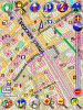
نقشه ی کامل ایالت های عرب
39.gif
برای استفاده با برنامه ی Navigon (همراه نقشه ها هستش)

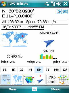
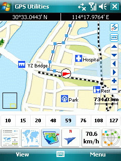
Gulf States (Kuwait, Saudi Arabia, Qatar, UAE, Oman & Bahrain) Maps to use with Navigon Navigation Software. Gulf State Maps with Navigon 5.2.6 Software. Also included Key Generator which allow to use all World Maps released by Navigon.
Download Instructions: Copy Map folder in SD card Just give any name for folder e.g Navigon.
Unzip and copy CAB file in ur PPC and run from PPC. After installation run keygen from ppc to get registration key, run navigon and apply serial number now u have Registered version Wink

Total File size is 36MB iwhich includes:
1. English_WM5_MN526 MN|5.2.6 for Windows Mobile 2005
2. English_2003_MN526 MN|5.2.6 for Windows Mobile 2003
3. gh_nm5_world_2002_2003_keygen
کد:
http://rapidshare.de/files/37305480/Navigon.rar.html
http://www.4shared.com/file/5184452/99ee2206/navigon.html
 

X_Farhad

Pocket PC کاربر فعال
کاربر فعال
تاریخ عضویت
23 آگوست 2003
نوشته‌ها
3,028
لایک‌ها
4
این برنامه رو قبلاً بهروز جان معرفی کردن. این ورژن جدیدشه

GPS Tuner is an off-road navigation software for Pocket PC devices. While most car navigation software gives you the possibility of planning your route based on a road network, GPS Tuner gives you the ability of navigation where the roads end.
6440_GPS_Tuner_1.gif

GPS Tuner is an excellent tool for hiking, geocaching, boating, flying, driving and many other sporting activities, where the monitoring of duration, distance and speed can be important.
If you are in possession of our ‘Geo license’ with extended features, the Area Calculation function is available to you, which makes it easy to measure perimeter and area. All you need to do is activate GPS and walk (or drive) around the boundary. The created area (shape) can be saved, exported in DXF format and even reloaded.
Version history
Revision N:
- Map loading speed is improved (maps under 1500x1500 are entirely loaded if possible)
- Walking position filter is applied only when "GPS Filter" is enabled
- Processing of Auto map folder is fixed

کد:
http://rapidshare.com/files/13964085/GPSTuner_v50n.rar
 

X_Farhad

Pocket PC کاربر فعال
کاربر فعال
تاریخ عضویت
23 آگوست 2003
نوشته‌ها
3,028
لایک‌ها
4
BeeLineGPS is a high performance Pocket PC cache navigation and management software tool. Import GPX files and manage thousands of waypoints with the advanced Waypoint Manger
2eciskp.gif

BeeLineGPS waypoint database can support thousands of waypoints with over 120 icons to depict specific locations. If you don't see a specific icon, ask for it and we'll add it.
BeeLineGPS has specific features to help the Geocacher find and manage the cache. With many Geocache icons, BeeLineGPS can help identify found, attempted, new and other cache states. Below shows the states and icons associated with these states. BeeLineGPS will also show detailed information using the web browser for each cache by simply clicking on the cache waypoint on the map. Using the GoTo waypoint feature along with the map screen, you can zero in on to the cache using the on-screen direction finder.

* View Geocache Information as seen in the original website
* Export tracks to Google Earth XML format
* Comprehensive Trip Computer
* Advanced Analysis Plotting
* Import GPX files with geocaching support
* Advanced Waypoint Management​

کد:
http://rapidshare.com/files/20726997/BeeLineGPS.v1.80.Build.115.rar.html
 

kelark

Pocket PC کاربر فعال- فروشنده معتبر
کاربر فعال
تاریخ عضویت
26 اکتبر 2006
نوشته‌ها
829
لایک‌ها
16
محل سکونت
Kent farm , Smallville , Shiraz
با اجازه آقا بهروز و اقا فرهاد بزرگان این تاپیک ، چند تا برنامه ی GPS دیدم گفتم بزارم شاید بدرد بخوره اگه تکراری یا کاربردی در ایران نداشتند به بزرگی خودتون ببخشید .​
Navitel 2.0 build 2.27

Supports Garmin & Russa maps

4cug30y.jpg


Main satellite navigation functions

coordinates of current location
ETA, heading and distance towards the destination point
speed and movement direction, altitude above the sea level
exact time and date
sunrise and sunset
and much more

The software is optimized for PDA display

Fast zooming and map browsing
Automatic transition through several maps
Choice for map display - track up, or North up
Floating help balloons
Several map objects search methods available
Nearest places within a set range
Cities and objects within cities (by type and by name). By post address
Navigation functions (available with a GPS only
Automatic routing with voice prompts
Speed and heading
Coordinates (latitude and longitude, altitude above sea level
Automatic time-zone detection
Trip computer: distance passed, time spent, speed, and other
Track recording, waypoints
Heading towards the destination point, and ETA
Information on GPS satellites' status

Simple, yet functional, customizable interface

Option to operate the program without the stylus pen (big buttons on the touch screen, very useful for drivers), as well as with the stylus through a classic Pocket PC menu screen.
Day and night map views
English language interface (also available in Russian, German and Portuguese) Voice prompts.
Automatic detection of GPS module's protocol and COM-port

Hardware requirements

Pocket PC 2003, 2003 SE, Windows Mobile 2005 (including Pocket PC smartphones with touchpad screens)
From 1 to 10 MBytes of RAM (depending on the map loaded)
Support for VGA mode (640x480), portrait/landscape view, as well as square screen 240х240
GPS-receivers: support for NMEA-0183, SiRF binary and Garmin; external module can be connected through the serial port, USB, BlueTooth, as well as CompactFlash, SDIO
Maps are stored in compact vector NTM proprietory format, using minimal space

دانلود​
کد:
http://share.gulli.com/dl/files/745085034

پسورد : leon@rd0
Credits : tsrh​
 

pshivaee

کاربر تازه وارد
تاریخ عضویت
5 دسامبر 2006
نوشته‌ها
22
لایک‌ها
0

فایل های ضمیمه

  • 16776_PocketGPSForMoscow_1.gif
    16776_PocketGPSForMoscow_1.gif
    67 KB · نمایش ها: 926

pshivaee

کاربر تازه وارد
تاریخ عضویت
5 دسامبر 2006
نوشته‌ها
22
لایک‌ها
0
Requirements: Microsoft Windows™ Mobile 2003
نرم افزاری برای نشان دادن ارتفاع، سرعت و اطلاعات ماهواره ای

*30,000 POI entries
*Raw Satellite Data Export
*Built-in Distance and Course calculator
*Very fast operation
*GPS Data Integrity checking
*Small footprint
*Modular Design with Expansion possibilities
*30,000 Multi-leg Route entries
*Future versions will include Dynamic Mapping and Trackback from Routes
*Future versions will include Connectivity to Digital Cameras
*Compact dashboard display with loads of data

اطلاعات بیشتر
http://www.trafficgateway.biz/products/tgps.html


دنلود
http://rapidshare.com/files/23293466/tGPS.zip.html

attachment.php


attachment.php
 

pshivaee

کاربر تازه وارد
تاریخ عضویت
5 دسامبر 2006
نوشته‌ها
22
لایک‌ها
0

pshivaee

کاربر تازه وارد
تاریخ عضویت
5 دسامبر 2006
نوشته‌ها
22
لایک‌ها
0
نقشه های جدید برای tomtom6
attachment.php


TomTom Maps v660.1219 without Europe Major Roads
Requirements: Any Windows Mobile PocketPc with TomTom v6 installed.
Overview: Our well known 1219 maps now without MRE (for those resisting to throw away their old 256 mb cards or with lack of space


More Info:

www.elrincondedey.es

Download Instructions: as usual download from links below

Canary Islands v.660.1219 <=== THIS IS A BRAND NEW MAP
ID=Canary_Islands.pna
513581024
660
build=1219
id=56634

http://rapidshare.com/files/19491679/Canary_Islands.rar

Iberia map v.660.1219
ID=Iberia.pna
1836716276
660
build=1219
id=56634

attachment.php


http://rapidshare.com/files/19225110/Iberia.part1.rar
http://rapidshare.com/files/19235898/Iberia.part2.rar


Map of France v.660.1219
ID=France.pna
1729609500
660
build=1219
id=56634

attachment.php


http://rapidshare.com/files/19199586/France.part1.rar
http://rapidshare.com/files/19210312/France.part2.rar


Map of Italy v.660.1219
ID=Italia.pna
1981876368
660
build=1219
id=56634

attachment.php


http://rapidshare.com/files/19168847/Italia.part1.rar
http://rapidshare.com/files/19179198/Italia.part2.rar


Map of Germany 660.1219
ID=Deutschland.pna
1659484405
660
build=1219
id=56634

http://rapidshare.com/files/19287771/Deutschland.part1.rar
http://rapidshare.com/files/19294276/Deutschland.part2.rar


Map of Scandinavia 660.1219
ID=Scandinavia.pna
1718022515
660
build=1219
id=56972

http://rapidshare.com/files/19247727/Scandinavia.part1.rar
http://rapidshare.com/files/19258841/Scandinavia.part2.rar


Map of Benelux 660.1219
ID=Benelux.pna
1064993321
660
build=1219
id=56634

attachment.php


http://rapidshare.com/files/19187588/Benelux.rar


Map of Alps region 660.1219
ID=Alps.pna
1728957725
660
build=1219
id=56634

attachment.php


http://rapidshare.com/files/19093157/Alps.part1.rar
http://rapidshare.com/files/19103242/Alps.part2.rar
http://rapidshare.com/files/19103834/Alps.part3.rar


Map of United Kingdom and Republic of Ireland 660.1219
ID=United_Kingdom_and_Republic_of_Ireland.pna
1728957725
660
build=1219
id=56634


http://rapidshare.com/files/19300193/United_Kingdom_and_Republic_of_Ireland.part1.rar
http://rapidshare.com/files/19300697/United_Kingdom_and_Republic_of_Ireland.part2.rar
 

pshivaee

کاربر تازه وارد
تاریخ عضویت
5 دسامبر 2006
نوشته‌ها
22
لایک‌ها
0
قابل توجه کسانی که با پارا گلایدر پرواز میکنند
اطلاعات بیشتر
http://www.winpilot.com/features.asp

همچنین:
Among the many features of WinPilot, competition pilots will enjoy the ability to fly close to the border of restricted airspace without entering it, clear representation of the task starting gate, detailed final glide computation around all the turnpoints , and an easy to use, yet very powerful task editor, that allows performing quick "what-if" calculations, that are especially important during the POST tasks. The 3D Climb Maximizer allows increasing of the rate of climb, and 3D Wind Display makes it easier to adjust the working band to take advantage of winds at different altitudes. Recreational pilots will also enjoy the increased safety and peace of mind coming from always knowing which airports and landing sites are within reach from the current position and altitude (without having to press a single button).
- Now with Color Maps of the entire World!
- Airspace vertical and horizontal proximity warnings
- Mobile Turnpoints simplify flying AAT and POST tasks
- links to your GPS for current moving map position, and visual depiction of surrounding airspace class
- final glide around multiple turnpoints - instant display of data at different McCready Settingsgraphical final glide indicator
- automatic wind calculation
- instant readout of tail/headwind (WP Pro)
- Climb Maximizer (WP Pro)
- 3D Wind Display


دنلود:
WinPilot PRO For Gliders v8.01
http://rapidshare.com/files/22207873/WinPilot_PRO_For_Gliders_.rar

WinPilot ADV For Gliders v8.01
http://rapidshare.com/files/22208946/WinPilot.ADV.For.Gliders.v8.01.rar

attachment.php
 

pshivaee

کاربر تازه وارد
تاریخ عضویت
5 دسامبر 2006
نوشته‌ها
22
لایک‌ها
0

pshivaee

کاربر تازه وارد
تاریخ عضویت
5 دسامبر 2006
نوشته‌ها
22
لایک‌ها
0
برای کسانی که قایق و کشتی سواری، می کنند.

اطلاعات بیشتر
http://www.garmin.com/cartography/mapSource/bluechartAtlantic.jsp

Download, uncompress files into ISO. Install with this key. ZGPCG-6HGP2-WMWRU-VCQ33-346Y7
Install onto PPC. Use GPSGATE to output to virtual port, Garmin protocol with unit ID # 0 (zero). Connect Garmin Que via the virtual port. NOTE: BE SURE TO RUN GPSGATE BEFORE RUNNING GARMIN QUE or the unit ID will not match the key and it will not unlock.
Code:
http://rapidshare.com/files/22023456/BC_Atlantic_v8.part1.rar.html
Code:
http://rapidshare.com/files/22028185/BC_Atlantic_v8.part2.rar.html
Code:
http://rapidshare.com/files/22030291/BC_Atlantic_v8.part3.rar.html
Code:
http://rapidshare.com/files/22031371/BC_Atlantic_v8.part4.rar.html


Mirrors:
Code:
part 1: http://www.megaupload.com/?d=YZBHSGRA
part 2: http://www.megaupload.com/?d=Q7PEVICJ
part 3: http://www.megaupload.com/?d=GFWQ78I5
part 4: http://www.megaupload.com/?d=WFTQPCE3

attachment.php
 

pshivaee

کاربر تازه وارد
تاریخ عضویت
5 دسامبر 2006
نوشته‌ها
22
لایک‌ها
0
Requirements: Windows Mobile 2003/SE/WM5 PocketPC
اطلاعات بیشتر
دنلود

Download Instructions: Install , replace , Enter ur name (must be more 6 char. ex hdfhdf) and any 10 digits ex. (1234567890)

attachment.php
 

pshivaee

کاربر تازه وارد
تاریخ عضویت
5 دسامبر 2006
نوشته‌ها
22
لایک‌ها
0
Requirements: Windows Mobile 200x / .NET CF

اطلاعات بیشتر

دنلود

Automatic and manual recording of field outlines, pathes and fixpoints by GPS

- The whole enterprise on the Pocket PC:

- DeltaArea stores an arbitrary number of areas, lines and points into a single map file.

- Better overview by colored figures

- Automatic deteccion of the GPS receiver

- Easy handling without stylus:
The Pocket PC is usually handled with the stylus. Outdoor on the field this is ineligible and furthermore it's dangerous while driving in a car.

- Buttons and dialogs are designed to allow handling with only the finger.

-Like a mobile phone:
Take the Pocket PC in your right hand. Then all relevant functions of DeltaArea may be handled by the thumb

attachment.php
attachment.php
 

X_Farhad

Pocket PC کاربر فعال
کاربر فعال
تاریخ عضویت
23 آگوست 2003
نوشته‌ها
3,028
لایک‌ها
4
دوستان لطفاً برنامه های مرتبط به GPS و نقشه ها رو ازین به بعد در این ترد معرفی کنید ، بلینکید !
 

X_Farhad

Pocket PC کاربر فعال
کاربر فعال
تاریخ عضویت
23 آگوست 2003
نوشته‌ها
3,028
لایک‌ها
4
Digital compass, speedometer with alarm, real-time map navigation... and MUCH more!

gpsutilppc_gpsinfo.gif
gpsutilppc_imagemap.gif


What's new in v1.25
• Fully supports Program Port on WM5 PPC
• Fixed "receive GPS data timeout" problem
• Fixed registration information lost problem on some devices
• Added Satellite Used information
• Added speed, course and altitude information to Track Log
• Improved Storage Location selection option
• Some small interface improvements & bugs fixed
• Fully supports Windows Mobile Pocket PC (2003, 2003SE, WM5), VGA (480x640) and horizontal screen

** این برنامه ی محبوب منه! می شه توسطش حتی قبل ازینکه دستگاه 3D Fix داده باشه، وضعیت ماهواره ها و قدرت امواج رو دید


دانلود
 

mehdirm666

Registered User
تاریخ عضویت
9 فوریه 2006
نوشته‌ها
592
لایک‌ها
1
محل سکونت
یه جای خوب
** این برنامه ی محبوب منه! می شه توسطش حتی قبل ازینکه دستگاه 3D Fix داده باشه، وضعیت ماهواره ها و قدرت امواج رو دید
فرهاد من این برنامه رو نصب کردم . فقط با بلوتوث جی پی اس کار میکنه . درسته ؟
 

X_Farhad

Pocket PC کاربر فعال
کاربر فعال
تاریخ عضویت
23 آگوست 2003
نوشته‌ها
3,028
لایک‌ها
4
فرهاد من این برنامه رو نصب کردم . فقط با بلوتوث جی پی اس کار میکنه . درسته ؟

نه مهدی جان فکر نمی کنم اینطور باشه

توی Menu-->GPS Setup باید تنظیمش کنی
اگه gps رو پیدا نمی کنه، تیک auto search رو بردار
و پورت gps رو دستی بهش بده
buadrate رو هم باید توی دفترچه راهنمای pda ت نوشته باشه
بعد بگو ببینم که درست شد یا نه
N_aggressive%20%2826%29.gif
 

mehdirm666

Registered User
تاریخ عضویت
9 فوریه 2006
نوشته‌ها
592
لایک‌ها
1
محل سکونت
یه جای خوب
نه مهدی جان فکر نمی کنم اینطور باشه

توی Menu-->GPS Setup باید تنظیمش کنی
اگه gps رو پیدا نمی کنه، تیک auto search رو بردار
و پورت gps رو دستی بهش بده
buadrate رو هم باید توی دفترچه راهنمای pda ت نوشته باشه
بعد بگو ببینم که درست شد یا نه
N_aggressive%20%2826%29.gif
آره درست شد . پورت رو دستی دادم .

راستی من همه ی دفترچه رو خوندم ولی این باد رت رو پیدا نکردم . چه جوریاس ؟

چند تا سوال دیگه دارم .
موقع لود نقشه پسوند مورد قبول فایل رو JPG,GIF,BMP,... میزنه . روی یه عکس معمولی چه طور نَویگیت میکنه ؟
بعد از کانکت شدن هیچ پوزیشنی رو نشون نمیده . چرا ؟
خودت از چه نقشه ای استفاده میکنی ؟
مرسی .
icon_exclaim.gif
 

X_Farhad

Pocket PC کاربر فعال
کاربر فعال
تاریخ عضویت
23 آگوست 2003
نوشته‌ها
3,028
لایک‌ها
4
موقع لود نقشه پسوند مورد قبول فایل رو JPG,GIF,BMP,... میزنه . روی یه عکس معمولی چه طور نَویگیت میکنه ؟
بعد از کانکت شدن هیچ پوزیشنی رو نشون نمیده . چرا ؟
خودت از چه نقشه ای استفاده میکنی ؟

روی عکس کافیه (حداقل) 2 تا Reference point بزاری تا عکس تبدیل بشه به "نقشه" ...
"بعد از کانکت شدن پوزیشن نشون نمی ده" ... متوجه نمی شم منظورتو مهدی جان... ولی بعد از کانکت شدن باید بعد یه مدت زمانی مختصاتت رو بهت نشون بده... اصلاً تاحالا سلامت GPS ت رو تست کردی؟ ترد GPS/سخت افزار رو ببین و با PC یه تستی بکن دستگاه رو...
بعدم شما که تهرانی می تونی از نقشه ی تهران Arcpad استفاده کنی، صفحه ی اول یا دوم همین ترد

من خودمم الان از هیچ نقشه ای استفاده نمی کنم، باید یه نقشه خودم درست کنم که هنوز وقت نکردم برم دنبالش
teef.gif
 
بالا